

Moab & La Sal Mountains Conditions Update December 28
What a tremendous Christmas gift we received for anyone who enjoys playing in the fluffy stuff. Up to 15″ of snow fell around the La Sals closing the Geyser Pass Road and making dreams come true in the back country. Fortunately, access to the Geyser Pass Winter Trailhead is clear now, so head up and enjoy the last of winter break. Cold weather has kept back country snow. Down at the shop, Moab Gear Trader has cross-country skis, ski wax and tuning supplies, snow shoes, back country skis, avalanche safety gear, sleds, snowboards, and the clothing you need to stay warm and dry. We are OPEN from 8 to 6 every day except New Year’s Day.
Weather
High pressure continues this week and a “chaotic” weather pattern this weekend. Temperatures were in the upper 30s today at the trailhead in the sun. In the shade was a lot cooler.
- Up to date forecast links:
- NOAA Forecast for [MOAB] [10,000′ in La Sals]
- Wunderground Forecast for [MOAB] [10,000′ in La Sals]
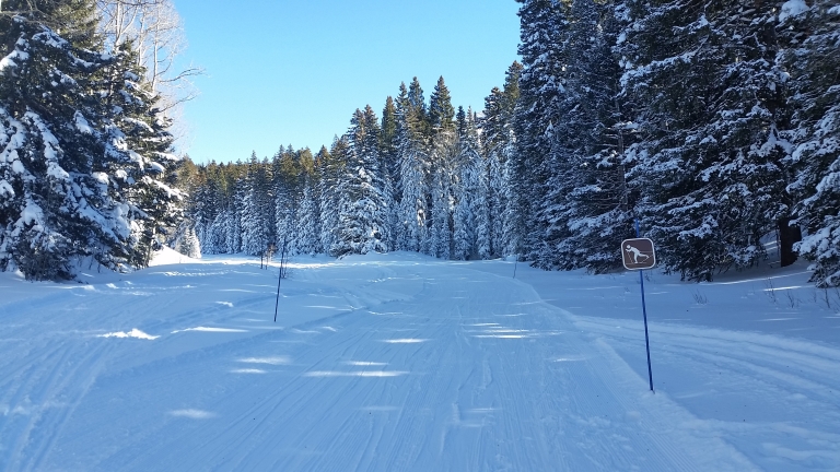
Road Conditions
- Geyser Pass Road – Last plowed 12/27/16. Snowpacked. Narrow in a few places. Be aware of false shoulders on the edge if you squeeze over to let someone past.
- Loop Road – Snowpacked & icy in spots on the upper elevations.
Grooming
- LUNA groomed the Lower Meadow and Gold Basin trails on Tuesday, 12-27. The track was in great shapes still on Wednesday evening. Thanks for the amazing job guys!
Snowpack
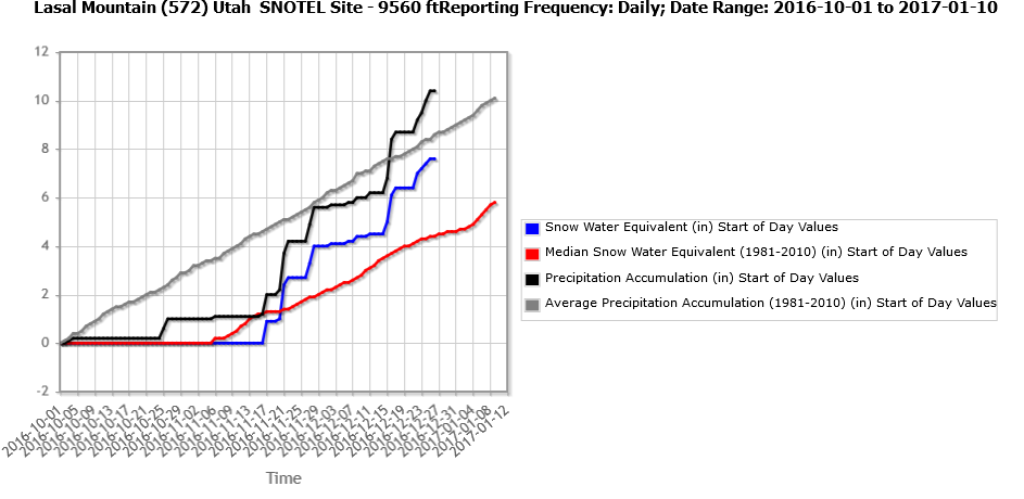
Water supply forecasts from The Colorado Basin River Forecast Center (www.cbrfc.noaa.gov) are at 87% for all Lake Powell Inflow, 85% for the Colorado at Cisco, 100% for the Green at Green, River UT, Yampa at Deerlodge 94%, and only 54% on the Salt River in Arizona.Great news for the La Sal mountains local snowpack with 169% of average. Basin wide statistics aren’t as exciting, but it could be worse. This graph shows SWE (Snow Water Equivalent) and Precipitation Accumulation. Basically the GREY (average) and BLACK (2016) lines are total Precipitation since Oct, 1st. Note the flat 0″ line until a doozy of a storm hit Oct, 25th with an inch of rain. The RED (Average) and BLUE (2016) lines show SWE. They are flat at 0″ until the Thanksgiving week storm on Nov, 17th. Quickly though, both of this years’ below average amounts quickly jump average where they are today. Another factor is the that this is the only data point for the La Sal Mountains and our storms seem to have been spotty and patchy, so conditions could vary from location to location. Now we will just wait and see how the January thaw will affect us.

Desert
Lack of low elevation snow has made temperature your only enemy for rock and sand based activities.


Leave A Comment